Akeman Park development

019 strategic constraints plan for DAS
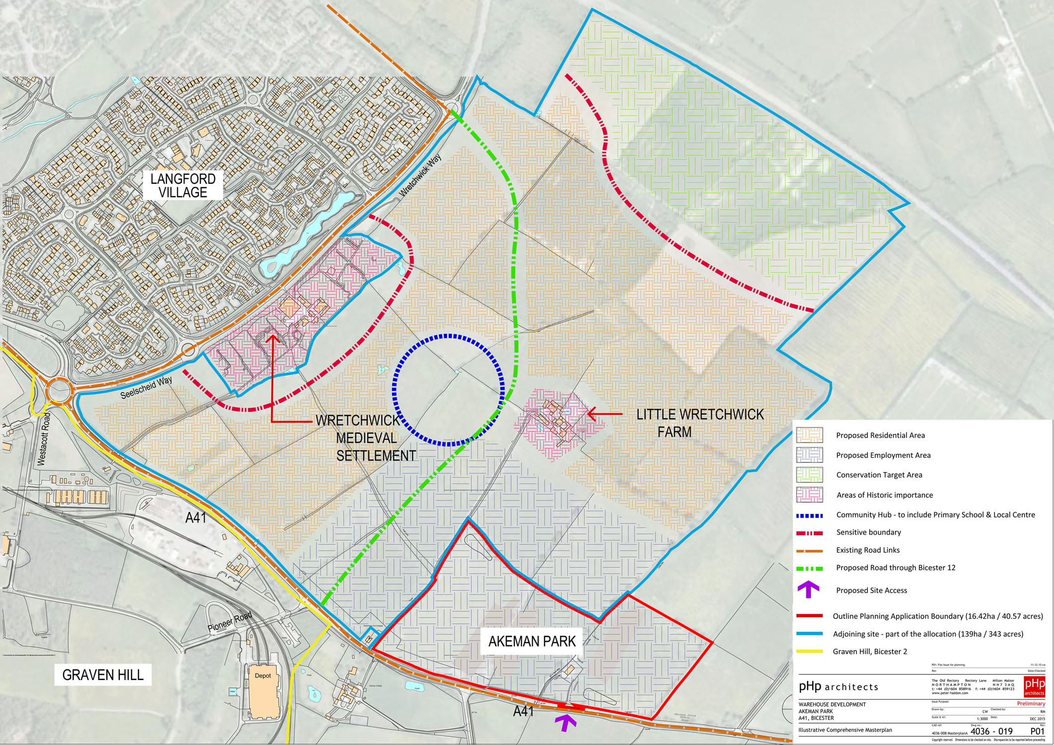
Further to the earlier post on proposals for the development of South East Bicester, a planning application covering part of this area (referred to as Akeman Park) has now been submitted to CDC. This application is for the erection of giant warehouses on farmland bordering the A41 at the southern end of the Bicester 12 development area (see here for location plan). Outline details of this development, shown at an exhibition held in November, can be viewed here (13Mb file – may be slow to download).
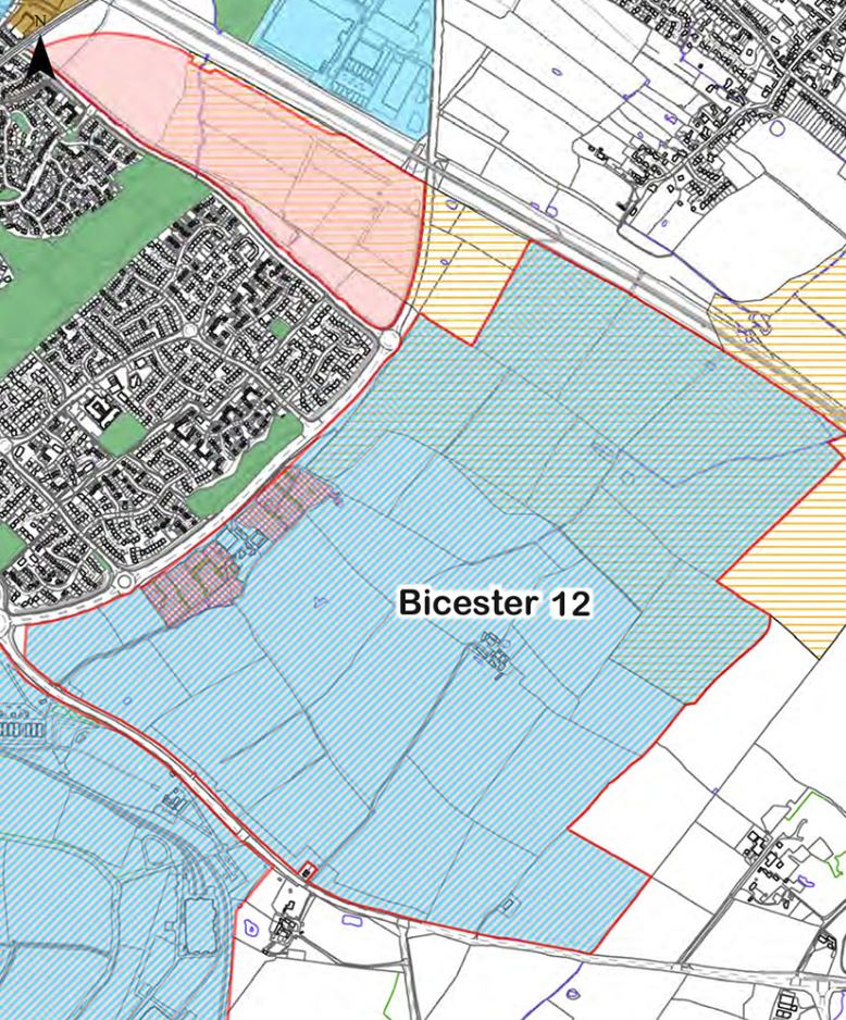
Details of the major development at Bicester 12, a separate proposal for 1500 homes opposite the A41 by Langford Village and referred to as Wretchwick Green, were shown at an exhibition held in October and can be viewed here. The planning application for this development is still awaited, and further details will be posted on the LVCA website when available. Representatives of the Wretchwick Green developers attended an LVCA meeting in November and were receptive to concerns raised by the LVCA committee, together with District and Town councillors, about some details of the proposals.

Full details of the Akeman Park application can now be viewed on the CDC website. Go to the CDC Planning Applications webpage  and enter “15/02316/OUT” in the Search box; further details of the application can accessed via the “Documents” tab. The last date for submitting comments and objections to CDC is Monday 25th January.

Among opponents to this Warehouse development are LVCA committee members and Bicester Town councillors, who regard it as inappropriate for this site. These huge warehouses range in size from 100,000 sq ft of floor space to over 300,000 sq ft and because warehousing is increasingly automated employment potential is limited. More than 200 parking and docking spaces for HGV’s provide an indication of the additional traffic that could be using Bicester’s road network 24 hours each day.

South East Bicester development – public exhibition

Bicester 12 map (small)The farmland area adjacent to Langford Village, at the other side of Wretchwick Way, is shown in the Cherwell Local Plan as Bicester 12 – South East Bicester. This site of approximately 155 hectares is allocated for mixed-use development, with proposals for 1500 houses together with business and industrial buildings, primarily storage and distribution.

A map showing  the Bicester 12 area, together with further details from the Cherwell Local Plan (July 2015) can be seen here.

Wates Developments and Redrow Homes are consulting on these developments and a Public Exhibition will be held on Tuesday 20th October 2.00-pm-7.00pm and Wednesday 21st October 2.00pm-8.00pm at Unit 7, Crown Walk, Bicester. See also http://www.wretchwickgreen.co.uk/

Bicester ward boundary changes

Cherwell Ward changesThe Local Government Boundary Commission for England (LGBCE) is currently carrying out an electoral review of Cherwell with the aim of revising ward boundaries to ensure that each councillor represents a similar number of voters.

Under proposals put forward by the LGBCE, by 2020 each ward in Cherwell would incorporate an electorate of around 7000 to 8000 and be represented by 3 councillors (see Draft recommendations for full figures & further details).

In Bicester this equates to around 30,000 voters, and the total number of councillors would increase from 11 to 12, while the number of wards would reduce from 5 to 4. In comparison, across rural areas in Cherwell the 15 existing wards would be cut to just 5 to achieve similar electorate levels. See here for maps showing the current and proposed Bicester ward boundaries.

Under the new proposals, Bicester South ward – currently consisting mainly of Langford – would expand to include Bicester Village and surrounding area, plus Kingsmere, Graven Hill and Ambrosden, while the current Bicester Town ward would disappear, absorbed by Bicester West, East and South wards.

The LGBCE is due to publish final recommendations in May 2015, and subject to parliamentary approval these would come into effect at local elections in 2016.

Gavray Meadows & SE Bicester

Gavray footpathFollowing the proposal to designate the Bicester 13 (Gavray Meadows) area east of Langford Brook as a Local Green Space, Cherwell District Council has published amended details for this area in the Local Plan “Further Proposed Modifications October 2014”, and the Gavray Meadows section can be viewed here.

On 16th December the reconvened Inspector’s Examination of the Cherwell Local Plan included discussion of the Gavray Drive proposals, and Pat Clissold, John Broad, Pam Roberts and Dominic Woodfield attended the meeting to present a local viewpoint on the plans to develop this site. While congratulating CDC for supporting the Local Green Space designation, concerns were expressed that this did not include the area between Gavray Drive and the public footpath, leaving a strip of ancient hedgerow land unprotected from future housing incursions.

The four representatives also spoke out against the plan to almost quadruple the size of Bicester 12 (farmland to the SE of Langford) from the original 400 homes to 1500, and the loss of the existing wildlife corridor in the Ray Conservation Target Area adjacent to the mainline railway. John and Pat protested against warehouses being built on Bicester 12, while John was also concerned about the proposed link road that would run past Bicester 12 from the A41 near Wendlebury to the Gavray Drive roundabout.

The provisional date for publication of the Inspector’s Report is March 2015.

A Gavray Meadows News page prepared by Pat Clissold showcases some of the wildlife on this site and can be viewed at https://www.facebook.com/WildLifeNewsGavrayMeadows.

Gavray Meadows – further news

Bicester 12.psdOn 20th October, John Broad and Pat Clissold gave a joint presentation to Cherwell District Council on a proposal to designate all of the Bicester 13 (Gavray Meadows) area east of Langford Brook as a Local Green Space. This is a new category in the National Policy Planning Framework to provide special protection against development for green areas of particular importance to local communities. John & Pat had proposed that the site was accepted for the richness of its wildlife and its historical record of old farming practices, and in particular for the site’s local significance.
Continue reading

Objections to CDC Local Plan modifications

Bicester 12.psdUPDATE: 28th September 2014

John Broad (see also previous guide to the CDC Local Plan, below) has additionally examined the National Planning Policy Framework (NPPF) and has identified points that can be used to challenge the legality of the revised Local Plan with regard to areas Bicester 12 & 13. See here for full details.

The NPPF sets out planning policies for England, and local planning authorities must ensure that their plans are compliant with this document.

UPDATE: 25th September 2014

An e-petition has been created by Pat Clissold to challenge the proposed developments at SE Bicester (Bicester 12) and Gavray Drive (Bicester 13). This can be viewed and signed at http://epetitions.direct.gov.uk/petitions/69041 .

UPDATE: 24th September 2014

Former LVCA committee member John Broad has compiled a comprehensive guide covering aspects of the modified CDC Local Plan that impact on Langford residents, identifying specific proposals that seem questionable, and providing guidance on the means of raising objections to these ahead of the forthcoming planning inquiry in December. See here for full details.

“I’ve attached a copy of my thoughts for residents to pick the bones out of. Of necessity I have kept it rather rambling as this means, hopefully, people will be able to pick out parts that they can include in their responses to the revised Local Plan in their own words. They can try to use the CDC official form or, probably easier, write a letter or email. As I’ve said, they must include their name and address and get them in before 5pm on Friday 3rd October.”  John Broad

ORIGINAL ARTICLE: 22nd September 2014

At the LVCA AGM on 17th September, Pat Clissold gave an update on Cherwell District Council’s proposals for development of the Gavray Drive meadows plus the large area of agricultural land to the SE of Langford Village.

These two areas adjacent to Langford are covered in the latest modifications to CDC’s Local Plan, which is now subject to consultation (see previous article “Gavray and SE Bicester developments” below).

To view the new proposals, visit http://www.cherwell.gov.uk/localplanexamination and download the two “Proposed Main Modifications” PDF files (alternatively, download here & here). Part 1 contains full details of the changes, while Part 2 shows maps of the affected areas, including “Bicester 12” (SE development) and “Bicester 13” (Gavray Drive).

Further details for “Bicester 12” and “Bicester 13” are covered in the Part 1 document from pages 79 to 87. Objections to these proposals can only be made in respect of the modifications, which are shown in blue type. Grounds for objections are limited, and the best options (which relate to “Bicester 12”) are probably as follows :

1.  Objection to the large increase in size of the development area from 40 hectares to 155 hectares.
2.  Objection to the expansion which extends to the railway line and thus blocks the wildlife corridor between the Local Wildlife Site Gavray 52W01 and the River Ray Conservation Target Area. This encroachment will lead to the decline and demise of wildlife.
3.  Objection that the character of the footpaths has not been respected. The prospect of a pleasurable country walk is replaced by passage through a housing estate.

For those interested in voicing objections, the “Representation Form” required to submit these to Cherwell District Council can be downloaded from the Local Plan Examination page link above. “Representations Guidance Notes” are also available here. When filling in this form, enter “Mod 88 / Page 128/129” at the beginning of “Part B” of the form to identify the proposed modification (Bicester 12). The deadline for comments is 3rd October 2014.

Planning practice guidance, setting out how Government planning policies for England should be applied, can be viewed at the National Planning Policy Framework website.

Gavray and SE Bicester Developments

Key Policies Map - Bicester.psdPat Clissold – responsible for previous website postings on the Gavray Drive development proposals – has provided an update on the current progress of this issue:

The original planning enquiry examining Cherwell District Council’s Local Plan for the period up to 2031, which included details of proposed housing growth for Bicester, was suspended in June this year when the planning inspector considered that the housing targets may be too low.

Following this, CDC has produced modifications to the Local Plan and is now consulting on these. Full details of these proposed modifications, plus other documents relating to the Local Plan are available to download from a single CDC website page dedicated to this.

Details of special relevance to Langford residents include the Gavray Meadows development and also SE Bicester, which is the large area of agricultural land to the other side of Wretchwick Way with an allocation of 1500 homes. Maps showing the SE Bicester and Gavray areas, designated “Bicester 12” and “Bicester 13” can be seen here. Additional details of the Gavray area can be seen here and here, and details of the SE Bicester area here.

A Map showing an overview of the Local Plan proposals for the whole of Bicester can be viewed here.

Residents now have until 3rd October to comment on the proposed modifications ahead of a meeting of the full council on 20th October when members will vote whether to accept the revisions. If agreed, these will be put to the Inspector when the hearing is expected to resume on 9th December.

Bicester Masterplan Consultation

Further to the earlier Bicester Masterplan Presentation, Cherwell District Council has now produced a Consultation Draft setting out the long-term vision for the town, which includes proposals for land bordering Langford Village. Exhibitions will be held in Bicester on the 20th & 22nd September, and comments on the Masterplan are invited.
For additional details of the Masterplan see here.